On September 1st, Taylor and I returned to the site of our first "real" SOTA activation almost a year later. Before climbing High Rock in late September 2011, my SOTA activities had been confined to one and two point locations where one had to make an effort to travel far enough from the vehicle to satisfy the spirit of the game. Until this fourth summit came along, I was able to carry way too much stuff the short distance from the vehicle to the operating location.
Activation Reports

Submitted by N7UN on
Summit:
"Llao is the god of the underworld in the mythology of the Klamath Native American tribe. Llao fought a great battle with the sky god, Skell, which caused the eruption of Mount Mazama, creating Crater Lake." (from Wikipedia ). I'm not sure of the correct pronuciation of "Llao".
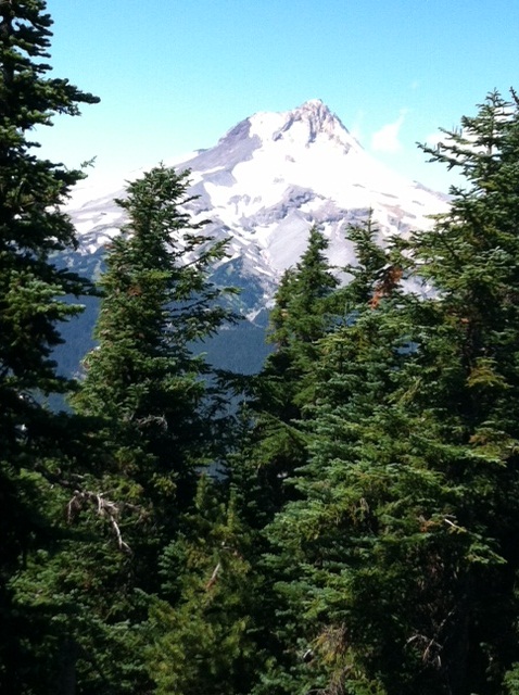
Submitted by N7UN on
Summit:
Aug 21, 2012
Overview:
Spectacular views of Mt Hood to the west and eastern Oregon from this north-south ridge. On clear days, Rainier, Adams, St Helens and the Oregon Cascade peaks are also visible.
Getting There

Submitted by KX7L on
Summit:
This one was a workout. The drive up was fairly straightforward: Exit 47 on I-90 to Tinkham Rd, then up the hill on NF-5510, until you reach the parking area and gate. NW Forest pass required.

Submitted by KK7DS on
Summit:
Black Butte is one of those mountains that is very recognizable and easy to spot on the horizon. Not because it has any disctinctive features, but rather because it has none. It looms darkly over the desert of central oregon as a perfect cone, easily distinguished from its sharp and craggy neighbors like Mt. Jefferson, Mt.

Submitted by NS7P on
Summit:
Hillman Peak is the highest summit on the rim of Crater Lake at over 8150' ASL. This pointed peak is not an easy climb, not because of the distance (1/2 to 3/4 mi) or elevation increase (less than 600'), but because it is so steep with a loose scree surface. Poles are essential to getting the traction to get up the slope.

Submitted by K7ATN on
Summit:
Barlow Ridge is a pleasant three mile or so hike (OW) east of Mount Hood with about 1000 feet gain. Although relatively close to Portland the trail is seldom used, (especially past Barlow Butte) and has a nice 'wild' character about it. In other words, the trail seldom sees maintenance. It's a leg stretcher with about 1000 feet of net gain, but quite a bit more elevation change with all the ups and downs along the ridge line. Quite a bit more.
Submitted by NS7P on
Summit:
My wife, Christina, and I hiked/climbed Llao rock for the views and the activation. For those new to this summit, this should be on your to do list. The 1 mile or so hike with about 700' of elevation rise is a moderate climb up a mostly meadowed hill. When you get to the top, the views are breathtaking. Note closure in 2013: http://www.pnwsota.org/blog/k7atn/2014-july-27/llao-rock-or-closed-public
Submitted by NS7P on
Summit:
My wife, Christina, and I climbed Mt Scott, the highest point in Crater Lake NP. At 8938' ASL, it is an 8 point summit (just shy of 10 points). The popular trail is moderate, climbing 1250' over 2.5 miles each way. The trees get smaller as you climb, and much of the trail is in sunlight. The trail winds and switchbacks up the west and south sides of the mountain, finally following a sharp ridgeline to the summit and its fire lookout.
Submitted by KK7DS on
Summit:
When a more complex plan failed to come to fruition Friday night, we decided late that we would head to Lookout Mountain in Oregon for Saturday's activation. We had been there before, and it is one of our all-time favorite SOTA summits. Just before we were heading out the door Saturday morning, I realized I had forgotten to alert us because the decision had been so late. I was shocked to see that K7ATN was scheduled for the same summit that day!